
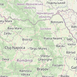
Distance between Vărbilău and Braşov
Distance from Vărbilău to Braşov is 36 miles / 58 kilometers.
Map showing the distance from Vărbilău to Braşov
| Air distance: | miles km |

Leaflet | © OpenStreetMap contributors
Vărbilău
| City: | Vărbilău |
| Country: | Romania |
| Coordinates: |
45°10′59″N 25°57′0″E |
Braşov
| City: | Braşov |
| Country: | Romania |
| Coordinates: |
45°38′54″N 25°36′22″E |
Time difference between Vărbilău and Braşov
There is no time difference between Vărbilău and Braşov. Current local time in Vărbilău and Braşov is 17:09 EET (2025-01-15)