
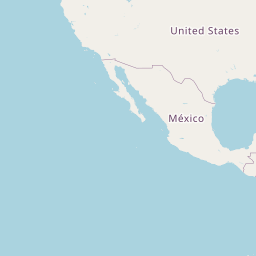
Distance between Tonaya and Licenciado Benito Juárez (Campo Gobierno)
Distance from Tonaya to Licenciado Benito Juárez (Campo Gobierno) is 407 miles / 655 kilometers.
Map showing the distance from Tonaya to Licenciado Benito Juárez (Campo Gobierno)
| Air distance: | miles km |


Leaflet | © OpenStreetMap contributors
Tonaya
| City: | Tonaya |
| Country: | Mexico |
Licenciado Benito Juárez (Campo Gobierno)
| City: | Licenciado Benito Juárez (Campo Gobierno) |
| Country: | Mexico |
Time difference between Tonaya and Licenciado Benito Juárez (Campo Gobierno)
The time difference between Tonaya and Licenciado Benito Juárez (Campo Gobierno) is 1 hour. Licenciado Benito Juárez (Campo Gobierno) is 1 hour behind Tonaya. Current local time in Tonaya is 14:15 CST (2025-03-01) and time in Licenciado Benito Juárez (Campo Gobierno) is 13:15 MST (2025-03-01).