
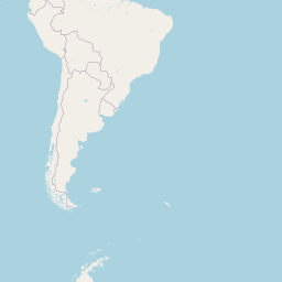
Distance between Toay and Ribeirão da Ilha
Distance from Toay to Ribeirão da Ilha is 1113 miles / 1790 kilometers.
Map showing the distance from Toay to Ribeirão da Ilha
| Air distance: | miles km |


Leaflet | © OpenStreetMap contributors
Toay
| City: | Toay |
| Country: | Argentina |
Ribeirão da Ilha
| City: | Ribeirão da Ilha |
| Country: | Brazil |
Time difference between Toay and Ribeirão da Ilha
There is no time difference between Toay and Ribeirão da Ilha. Current local time in Toay and Ribeirão da Ilha is 17:59 -03 (2025-02-15)