
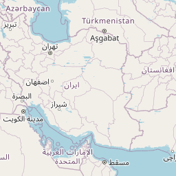
Distance between Takāb and Tabriz
Distance from Takāb to Tabriz is 125 miles / 200 kilometers.
Map showing the distance from Takāb to Tabriz
| Air distance: | miles km |


Leaflet | © OpenStreetMap contributors
Takāb
| City: | Takāb |
| Country: | Iran |
| Coordinates: |
36°24′3″N 47°6′47″E |
Tabriz
| City: | Tabriz |
| Country: | Iran |
| Coordinates: |
38°4′48″N 46°17′30″E |
Time difference between Takāb and Tabriz
There is no time difference between Takāb and Tabriz. Current local time in Takāb and Tabriz is 14:53 +0330 (2025-01-12)