
Distance between Sandīla and Mymensingh
Distance from Sandīla to Mymensingh is 635 miles / 1022 kilometers.
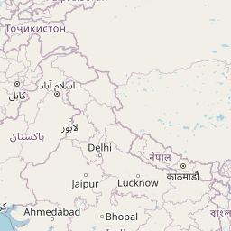
Map showing the distance from Sandīla to Mymensingh
| Air distance: | miles km |

Leaflet | © OpenStreetMap contributors
Sandīla
| City: | Sandīla |
| Country: | India |
Mymensingh
| City: | Mymensingh |
| Country: | Bangladesh |
Time difference between Sandīla and Mymensingh
The time difference between Sandīla and Mymensingh is 30 minutes. Mymensingh is 30 minutes ahead of Sandīla. Current local time in Sandīla is 05:21 IST (2025-02-18) and time in Mymensingh is 05:51 +06 (2025-02-18).