
Distance between Reyhanlı and Ālbū Kamāl
Distance from Reyhanlı to Ālbū Kamāl is 275 miles / 443 kilometers.
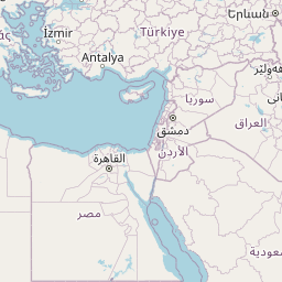
Map showing the distance from Reyhanlı to Ālbū Kamāl
| Air distance: | miles km |

Leaflet | © OpenStreetMap contributors
Reyhanlı
| City: | Reyhanlı |
| Country: | Turkey |
Ālbū Kamāl
| City: | Ālbū Kamāl |
| Country: | Syria |
Time difference between Reyhanlı and Ālbū Kamāl
There is no time difference between Reyhanlı and Ālbū Kamāl. Current local time in Reyhanlı and Ālbū Kamāl is 23:50 +03 (2025-02-18)