Distance between Pehlivanköy and Isparta
Distance from Pehlivanköy to Isparta is 902 miles / 1451 kilometers.
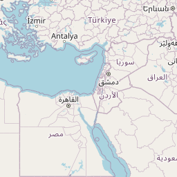
Map showing the distance from Pehlivanköy to Isparta
![]() |
Air distance: | miles km |
![](https://tile.openstreetmap.org/4/9/5.png)
![](https://tile.openstreetmap.org/4/10/5.png)
![](https://tile.openstreetmap.org/4/9/6.png)
![](https://tile.openstreetmap.org/4/10/6.png)
![](https://tile.openstreetmap.org/4/8/5.png)
![](https://tile.openstreetmap.org/4/11/5.png)
![](https://tile.openstreetmap.org/4/8/6.png)
![](https://tile.openstreetmap.org/4/11/6.png)
![](https://tile.openstreetmap.org/4/7/5.png)
![](https://tile.openstreetmap.org/4/12/5.png)
![](https://tile.openstreetmap.org/4/7/6.png)
![](https://tile.openstreetmap.org/4/12/6.png)
![](marker-shadow.png)
![](marker-icon.png)
Leaflet | © OpenStreetMap contributors
Pehlivanköy
City: | Pehlivanköy |
Country: | Turkey |
Isparta
City: | Isparta |
Country: | Turkey |
Time difference between Pehlivanköy and Isparta
There is no time difference between Pehlivanköy and Isparta. Current local time in Pehlivanköy and Isparta is 02:55 +03 (2025-02-18)