
Distance between Miān Channūn and Tāndā
Distance from Miān Channūn to Tāndā is 680 miles / 1095 kilometers.
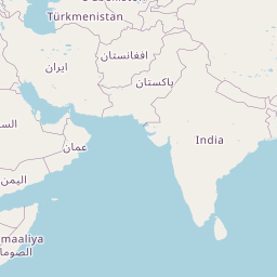
Map showing the distance from Miān Channūn to Tāndā
| Air distance: | miles km |


Leaflet | © OpenStreetMap contributors
Miān Channūn
| City: | Miān Channūn |
| Country: | Pakistan |
Tāndā
| City: | Tāndā |
| Country: | India |
Time difference between Miān Channūn and Tāndā
The time difference between Miān Channūn and Tāndā is 30 minutes. Tāndā is 30 minutes ahead of Miān Channūn. Current local time in Miān Channūn is 07:06 PKT (2025-02-18) and time in Tāndā is 07:36 IST (2025-02-18).