
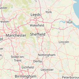
Distance between Ledston and Bentley
Distance from Ledston to Bentley is 17 miles / 28 kilometers.
Map showing the distance from Ledston to Bentley
| Air distance: | miles km |

Leaflet | © OpenStreetMap contributors
Ledston
| City: | Ledston |
| Country: | United Kingdom |
| Coordinates: |
53°45′9″N 1°20′36″W |
Bentley
| City: | Bentley |
| Country: | United Kingdom |
| Coordinates: |
53°31′59″N 1°9′0″W |
Time difference between Ledston and Bentley
There is no time difference between Ledston and Bentley. Current local time in Ledston and Bentley is 04:08 GMT (2025-01-11)