
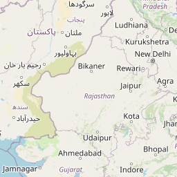
Distance between Kota and Tonk
Distance from Kota to Tonk is 68 miles / 110 kilometers.
Map showing the distance from Kota to Tonk
| Air distance: | miles km |


Leaflet | © OpenStreetMap contributors
Kota
| City: | Kota |
| Country: | India |
| Coordinates: |
25°10′57″N 75°50′20″E |
Tonk
| City: | Tonk |
| Country: | India |
| Coordinates: |
26°9′58″N 75°47′17″E |
Time difference between Kota and Tonk
There is no time difference between Kota and Tonk. Current local time in Kota and Tonk is 19:16 IST (2025-01-14)