
Distance between Gandajika and Boma
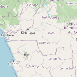
Distance from Gandajika to Boma is 751 miles / 1209 kilometers.
Map showing the distance from Gandajika to Boma
| Air distance: | miles km |


Leaflet | © OpenStreetMap contributors
Gandajika
| City: | Gandajika |
| Country: | Democratic Republic of the Congo |
Boma
| City: | Boma |
| Country: | Democratic Republic of the Congo |
Time difference between Gandajika and Boma
The time difference between Gandajika and Boma is 1 hour. Boma is 1 hour behind Gandajika. Current local time in Gandajika is 02:39 CAT (2025-01-18) and time in Boma is 01:39 WAT (2025-01-18).