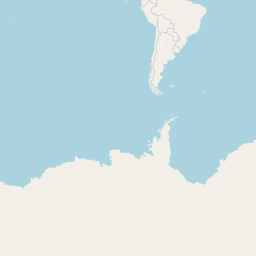
Distance between Chincha Alta and Manizales
Distance from Chincha Alta to Manizales is 1277 miles / 2056 kilometers.
Map showing the distance from Chincha Alta to Manizales
![]() |
Air distance: | miles km |
![](https://tile.openstreetmap.org/1/0/0.png)
![](https://tile.openstreetmap.org/1/1/0.png)
![](https://tile.openstreetmap.org/1/0/1.png)
![](https://tile.openstreetmap.org/1/1/1.png)
![](https://tile.openstreetmap.org/1/1/0.png)
![](https://tile.openstreetmap.org/1/0/0.png)
![](https://tile.openstreetmap.org/1/1/1.png)
![](https://tile.openstreetmap.org/1/0/1.png)
![](https://tile.openstreetmap.org/1/0/0.png)
![](https://tile.openstreetmap.org/1/1/0.png)
![](https://tile.openstreetmap.org/1/0/1.png)
![](https://tile.openstreetmap.org/1/1/1.png)
![](marker-shadow.png)
![](marker-icon.png)
Leaflet | © OpenStreetMap contributors
Chincha Alta
City: | Chincha Alta |
Country: | Peru |
Manizales
City: | Manizales |
Country: | Colombia |
Time difference between Chincha Alta and Manizales
There is no time difference between Chincha Alta and Manizales. Current local time in Chincha Alta and Manizales is 18:52 -05 (2025-02-17)