
Cities close to Minh Lương
Cities, towns and suburbs near Minh Lương. An Biên: 14 kilometers (9 miles), Rạch Giá: 15 kilometers (9 miles), Giồng Riềng: 17 kilometers (11 miles).
| Cities / towns / suburbs around Minh Lương | Kilometers | Miles |
|---|---|---|
| How far is An Biên from Minh Lương | 14 | 9 |
| How far is Rạch Giá from Minh Lương | 15 | 9 |
| How far is Giồng Riềng from Minh Lương | 17 | 11 |
| How far is Gò Quao from Minh Lương | 23 | 14 |
| How far is Tân Hiệp from Minh Lương | 28 | 17 |
| How far is Cờ Đỏ from Minh Lương | 36 | 23 |
| How far is Vị Thanh from Minh Lương | 36 | 23 |
| How far is Thứ Mười Một from Minh Lương | 40 | 25 |
| How far is Ngoc Hon Doc from Minh Lương | 40 | 25 |
| How far is Núi Sập from Minh Lương | 42 | 26 |
Closest airport to Minh Lương
| Airport | Kilometers | Miles |
|---|---|---|
| Rach Gia Airport (VKG) | 6.9 | 4.3 |
| Can Tho International Airport (VCA) | 63.9 | 39.7 |
| Cà Mau Airport (CAH) | 80.7 | 50.2 |
Location
Coordinates:
Latitude: 9°54′8″N
Longitude: 105°9′34″E
Map
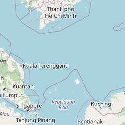

Leaflet | © OpenStreetMap contributors
Time
Current local time in Minh Lương:
Time: 22:04 +07
Date: 2025-03-21
Sunrise and Sunset
| Date | Sunrise | Sunset |
|---|---|---|
| 2025-03-21 (Today) | 06:01 | 18:11 |
| 2025-03-22 (Tomorrow) | 06:01 | 18:11 |
| 2025-03-23 | 06:00 | 18:11 |
| 2025-03-24 | 06:00 | 18:11 |
| 2025-03-25 | 05:59 | 18:11 |
| 2025-03-26 | 05:58 | 18:11 |
| 2025-03-27 | 05:58 | 18:11 |