
Cities close to Li
Cities, towns and suburbs near Li. Thung Hua Chang: 24 kilometers (15 miles), Doi Tao: 33 kilometers (20 miles), Thoen: 35 kilometers (22 miles).
| Cities / towns / suburbs around Li | Kilometers | Miles |
|---|---|---|
| How far is Thung Hua Chang from Li | 24 | 15 |
| How far is Doi Tao from Li | 33 | 20 |
| How far is Thoen from Li | 35 | 22 |
| How far is Sop Prap from Li | 42 | 26 |
| How far is Soem Ngam from Li | 43 | 27 |
| How far is Mae Phrik from Li | 43 | 27 |
| How far is Hot from Li | 56 | 35 |
| How far is Ban Hong from Li | 60 | 38 |
| How far is Om Koi from Li | 63 | 39 |
| How far is Sam Ngao from Li | 63 | 39 |
Closest airport to Li
| Airport | Kilometers | Miles |
|---|---|---|
| Lampang Airport (LPT) | 78.4 | 48.7 |
| Chiang Mai International Airport (CNX) | 107.3 | 66.7 |
| Sukhothai Airport (THS) | 111.5 | 69.3 |
Distance from Li to other municipalities
| Municipality | Kilometers | Miles |
|---|---|---|
| How far is Lamphun from Li | 87 | 54 |
| How far is Chiang Mai from Li | 110 | 68 |
Location
Coordinates:
Latitude: 17°48′9″N
Longitude: 98°57′3″E
Map


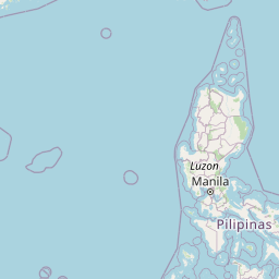


Leaflet | © OpenStreetMap contributors
Time
Current local time in Li:
Time: 19:55 +07
Date: 2025-03-21
Sunrise and Sunset
| Date | Sunrise | Sunset |
|---|---|---|
| 2025-03-21 (Today) | 06:26 | 18:36 |
| 2025-03-22 (Tomorrow) | 06:25 | 18:36 |
| 2025-03-23 | 06:24 | 18:36 |
| 2025-03-24 | 06:23 | 18:37 |
| 2025-03-25 | 06:23 | 18:37 |
| 2025-03-26 | 06:22 | 18:37 |
| 2025-03-27 | 06:21 | 18:37 |