
Cities close to Mpanda
Cities, towns and suburbs near Mpanda. Sumbawanga: 190 kilometers (118 miles), Kigoma: 228 kilometers (142 miles), Tabora: 244 kilometers (152 miles).
| Cities / towns / suburbs around Mpanda | Kilometers | Miles |
|---|---|---|
| How far is Sumbawanga from Mpanda | 190 | 118 |
| How far is Kigoma from Mpanda | 228 | 142 |
| How far is Tabora from Mpanda | 244 | 152 |
| How far is Mbeya from Mpanda | 387 | 240 |
| How far is Shinyanga from Mpanda | 396 | 246 |
| How far is Geita from Mpanda | 405 | 252 |
| How far is Singida from Mpanda | 441 | 274 |
| How far is Mwanza from Mpanda | 471 | 293 |
| How far is Bariadi from Mpanda | 509 | 317 |
| How far is Dodoma from Mpanda | 517 | 321 |
Closest airport to Mpanda
| Airport | Kilometers | Miles |
|---|---|---|
| Kalemie Airport (FMI) | 208.0 | 129.3 |
| Kigoma Airport (TKQ) | 227.5 | 141.4 |
| Tabora Airport (TBO) | 241.0 | 149.7 |
Distance from Mpanda to other municipalities
| Municipality | Kilometers | Miles |
|---|---|---|
| How far is Tabora from Mpanda | 244 | 152 |
| How far is Uvinza from Mpanda | 157 | 98 |
| How far is Kasulu from Mpanda | 224 | 139 |
| How far is Mbeya from Mpanda | 387 | 240 |
| How far is Inyonga from Mpanda | 118 | 73 |
| How far is Tunduma from Mpanda | 378 | 235 |
| How far is Mwanza from Mpanda | 471 | 293 |
| How far is Sumbawanga from Mpanda | 190 | 118 |
| How far is Singida from Mpanda | 441 | 274 |
| How far is Karema from Mpanda | 88 | 54 |
Location
Coordinates:
Latitude: 6°20′37″S
Longitude: 31°4′10″E
Map
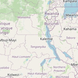


Leaflet | © OpenStreetMap contributors
Time
Current local time in Mpanda:
Time: 15:28 EAT
Date: 2025-02-23
Sunrise and Sunset
| Date | Sunrise | Sunset |
|---|---|---|
| 2025-02-23 (Today) | 07:00 | 19:17 |
| 2025-02-24 (Tomorrow) | 07:00 | 19:17 |
| 2025-02-25 | 07:00 | 19:17 |
| 2025-02-26 | 07:00 | 19:16 |
| 2025-02-27 | 07:00 | 19:16 |
| 2025-02-28 | 07:00 | 19:16 |
| 2025-03-01 | 07:00 | 19:15 |