
Cities close to Yovon
Cities, towns and suburbs near Yovon. Norak: 26 kilometers (16 miles), Somoniyon: 27 kilometers (17 miles), Vahdat: 27 kilometers (17 miles).
| Cities / towns / suburbs around Yovon | Kilometers | Miles |
|---|---|---|
| How far is Norak from Yovon | 26 | 16 |
| How far is Somoniyon from Yovon | 27 | 17 |
| How far is Vahdat from Yovon | 27 | 17 |
| How far is Dushanbe from Yovon | 33 | 21 |
| How far is Fayzobod from Yovon | 36 | 22 |
| How far is Danghara from Yovon | 36 | 22 |
| How far is Obikiik from Yovon | 37 | 23 |
| How far is Abdurahmoni Jomí from Yovon | 46 | 28 |
| How far is Hisor from Yovon | 48 | 30 |
| How far is Sarband from Yovon | 50 | 31 |
Closest airport to Yovon
| Airport | Kilometers | Miles |
|---|---|---|
| Dushanbe International Airport (DYU) | 31.6 | 19.6 |
| Bokhtar International Airport (KQT) | 52.1 | 32.4 |
| Kulob Airport (TJU) | 76.3 | 47.4 |
Distance from Yovon to other municipalities
| Municipality | Kilometers | Miles |
|---|---|---|
| How far is Ishqoshim from Yovon | 288 | 179 |
| How far is Moskovskiy from Yovon | 88 | 55 |
| How far is Chkalov from Yovon | 221 | 137 |
| How far is Khŭjand from Yovon | 225 | 140 |
| How far is Proletar from Yovon | 210 | 130 |
| How far is Tursunzoda from Yovon | 74 | 46 |
| How far is Boshkengash from Yovon | 26 | 16 |
| How far is Chubek from Yovon | 97 | 60 |
| How far is Danghara from Yovon | 36 | 22 |
| How far is Dushanbe from Yovon | 33 | 21 |
Location
Coordinates:
Latitude: 38°18′50″N
Longitude: 69°2′16″E
Map
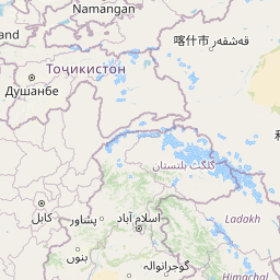

Leaflet | © OpenStreetMap contributors
Time
Current local time in Yovon:
Time: 19:42 +05
Date: 2025-03-21
Sunrise and Sunset
| Date | Sunrise | Sunset |
|---|---|---|
| 2025-03-21 (Today) | 06:24 | 18:37 |
| 2025-03-22 (Tomorrow) | 06:22 | 18:38 |
| 2025-03-23 | 06:21 | 18:39 |
| 2025-03-24 | 06:19 | 18:40 |
| 2025-03-25 | 06:18 | 18:41 |
| 2025-03-26 | 06:16 | 18:42 |
| 2025-03-27 | 06:14 | 18:43 |