
Cities close to Ma‘lūlā
Cities, towns and suburbs near Ma‘lūlā. ‘Assāl al Ward: 12 kilometers (8 miles), Al Quţayfah: 13 kilometers (8 miles), Yabrūd: 17 kilometers (11 miles).
| Cities / towns / suburbs around Ma‘lūlā | Kilometers | Miles |
|---|---|---|
| How far is ‘Assāl al Ward from Ma‘lūlā | 12 | 8 |
| How far is Al Quţayfah from Ma‘lūlā | 13 | 8 |
| How far is Yabrūd from Ma‘lūlā | 17 | 11 |
| How far is Rankūs from Ma‘lūlā | 18 | 11 |
| How far is Jayrūd from Ma‘lūlā | 18 | 11 |
| How far is Ar Ruḩaybah from Ma‘lūlā | 18 | 11 |
| How far is Şaydnāyā from Ma‘lūlā | 23 | 14 |
| How far is An Nabk from Ma‘lūlā | 26 | 16 |
| How far is Aḑ Ḑumayr from Ma‘lūlā | 26 | 16 |
| How far is Douma from Ma‘lūlā | 33 | 21 |
Closest airport to Ma‘lūlā
| Airport | Kilometers | Miles |
|---|---|---|
| Damascus International Airport (DAM) | 48.4 | 30.1 |
| Beirut–Rafic Hariri International Airport (BEY) | 97.8 | 60.7 |
| Rosh Pina Airport (RPN) | 132.0 | 82.0 |
Location
Coordinates:
Latitude: 33°50′43″N
Longitude: 36°32′42″E
Map
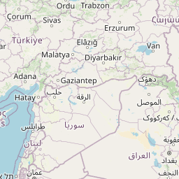

Leaflet | © OpenStreetMap contributors
Time
Current local time in Ma‘lūlā:
Time: 16:17 +03
Date: 2025-03-21
Sunrise and Sunset
| Date | Sunrise | Sunset |
|---|---|---|
| 2025-03-21 (Today) | 06:34 | 18:47 |
| 2025-03-22 (Tomorrow) | 06:33 | 18:48 |
| 2025-03-23 | 06:31 | 18:48 |
| 2025-03-24 | 06:30 | 18:49 |
| 2025-03-25 | 06:29 | 18:50 |
| 2025-03-26 | 06:27 | 18:51 |
| 2025-03-27 | 06:26 | 18:51 |