
Cities close to Al Ḩamrā’
Cities, towns and suburbs near Al Ḩamrā’. Şabbūrah: 21 kilometers (13 miles), As Si‘in: 27 kilometers (17 miles), Souran: 31 kilometers (19 miles).
| Cities / towns / suburbs around Al Ḩamrā’ | Kilometers | Miles |
|---|---|---|
| How far is Şabbūrah from Al Ḩamrā’ | 21 | 13 |
| How far is As Si‘in from Al Ḩamrā’ | 27 | 17 |
| How far is Souran from Al Ḩamrā’ | 31 | 19 |
| How far is Sinjār from Al Ḩamrā’ | 31 | 20 |
| How far is As Salamīyah from Al Ḩamrā’ | 34 | 21 |
| How far is At Tamāni‘ah from Al Ḩamrā’ | 35 | 21 |
| How far is Ḩamāh from Al Ḩamrā’ | 36 | 22 |
| How far is Barrī ash Sharqī from Al Ḩamrā’ | 39 | 24 |
| How far is Khān Shaykhūn from Al Ḩamrā’ | 42 | 26 |
| How far is Kafr Zaytā from Al Ḩamrā’ | 44 | 28 |
Closest airport to Al Ḩamrā’
| Airport | Kilometers | Miles |
|---|---|---|
| Aleppo International Airport (ALP) | 97.2 | 60.4 |
| Bassel Al-Assad International Airport (LTK) | 103.7 | 64.5 |
| Hatay Airport (HTY) | 137.4 | 85.4 |
Location
Coordinates:
Latitude: 35°18′54″N
Longitude: 37°5′10″E
Map
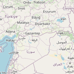

Leaflet | © OpenStreetMap contributors
Time
Current local time in Al Ḩamrā’:
Time: 17:01 +03
Date: 2025-03-21
Sunrise and Sunset
| Date | Sunrise | Sunset |
|---|---|---|
| 2025-03-21 (Today) | 06:32 | 18:45 |
| 2025-03-22 (Tomorrow) | 06:30 | 18:46 |
| 2025-03-23 | 06:29 | 18:46 |
| 2025-03-24 | 06:27 | 18:47 |
| 2025-03-25 | 06:26 | 18:48 |
| 2025-03-26 | 06:25 | 18:49 |
| 2025-03-27 | 06:23 | 18:50 |