
Cities close to Stenungsund
Cities, towns and suburbs near Stenungsund. Skärhamn: 18 kilometers (11 miles), Lilla Edet: 20 kilometers (12 miles), Henån: 20 kilometers (13 miles).
| Cities / towns / suburbs around Stenungsund | Kilometers | Miles |
|---|---|---|
| How far is Skärhamn from Stenungsund | 18 | 11 |
| How far is Lilla Edet from Stenungsund | 20 | 12 |
| How far is Henån from Stenungsund | 20 | 13 |
| How far is Alafors from Stenungsund | 22 | 14 |
| How far is Kungälv from Stenungsund | 24 | 15 |
| How far is Uddevalla from Stenungsund | 32 | 20 |
| How far is Lysekil from Stenungsund | 32 | 20 |
| How far is Trollhättan from Stenungsund | 36 | 23 |
| How far is Partille from Stenungsund | 41 | 25 |
| How far is Göteborg from Stenungsund | 41 | 26 |
Closest airport to Stenungsund
| Airport | Kilometers | Miles |
|---|---|---|
| Säve airport (GSE) | 33.1 | 20.5 |
| Trollhättan–Vänersborg Airport (THN) | 41.4 | 25.7 |
| Göteborg Landvetter Airport (GOT) | 53.0 | 32.9 |
Location
Coordinates:
Latitude: 58°4′13″N
Longitude: 11°49′5″E
Map
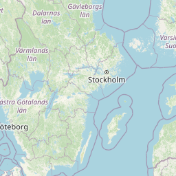


Leaflet | © OpenStreetMap contributors
Time
Current local time in Stenungsund:
Time: 15:57 CET
Date: 2025-03-21
Sunrise and Sunset
| Date | Sunrise | Sunset |
|---|---|---|
| 2025-03-21 (Today) | 06:08 | 18:30 |
| 2025-03-22 (Tomorrow) | 06:05 | 18:33 |
| 2025-03-23 | 06:03 | 18:35 |
| 2025-03-24 | 06:00 | 18:37 |
| 2025-03-25 | 05:57 | 18:39 |
| 2025-03-26 | 05:54 | 18:42 |
| 2025-03-27 | 05:51 | 18:44 |