
Cities close to Nieuw Nickerie
Cities, towns and suburbs near Nieuw Nickerie. Totness: 72 kilometers (45 miles), Groningen: 167 kilometers (104 miles), Lelydorp: 194 kilometers (121 miles).
| Cities / towns / suburbs around Nieuw Nickerie | Kilometers | Miles |
|---|---|---|
| How far is Totness from Nieuw Nickerie | 72 | 45 |
| How far is Groningen from Nieuw Nickerie | 167 | 104 |
| How far is Lelydorp from Nieuw Nickerie | 194 | 121 |
| How far is Paramaribo from Nieuw Nickerie | 200 | 124 |
| How far is Onverwacht from Nieuw Nickerie | 200 | 124 |
| How far is Nieuw Amsterdam from Nieuw Nickerie | 208 | 130 |
| How far is Brokopondo from Nieuw Nickerie | 241 | 150 |
| How far is Albina from Nieuw Nickerie | 326 | 203 |
Closest airport to Nieuw Nickerie
| Airport | Kilometers | Miles |
|---|---|---|
| Wageningen Airstrip (AGI) | 34.5 | 21.4 |
| Cheddi Jagan International Airport (GEO) | 155.4 | 96.6 |
| Eugene F. Correira International Airport (OGL) | 159.1 | 98.9 |
Distance from Nieuw Nickerie to other municipalities
| Municipality | Kilometers | Miles |
|---|---|---|
| How far is Groningen from Nieuw Nickerie | 167 | 104 |
| How far is Brownsweg from Nieuw Nickerie | 226 | 140 |
| How far is Albina from Nieuw Nickerie | 326 | 203 |
Location
Coordinates:
Latitude: 5°55′33″N
Longitude: 56°58′22″W
Map
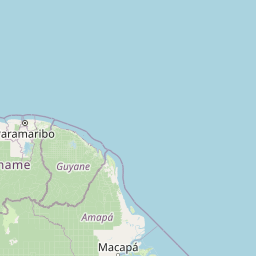


Leaflet | © OpenStreetMap contributors
Time
Current local time in Nieuw Nickerie:
Time: 09:47 -03
Date: 2025-02-19
Sunrise and Sunset
| Date | Sunrise | Sunset |
|---|---|---|
| 2025-02-19 (Today) | 07:01 | 19:01 |
| 2025-02-20 (Tomorrow) | 07:01 | 19:01 |
| 2025-02-21 | 07:01 | 19:01 |
| 2025-02-22 | 07:00 | 19:01 |
| 2025-02-23 | 07:00 | 19:01 |
| 2025-02-24 | 07:00 | 19:01 |
| 2025-02-25 | 07:00 | 19:01 |