
Cities close to Ramain
Cities, towns and suburbs near Ramain. Ditsaan: 1 kilometers (1 miles), Buadiposo-Buntong: 4 kilometers (3 miles), Molundo: 5 kilometers (3 miles).
| Cities / towns / suburbs around Ramain | Kilometers | Miles |
|---|---|---|
| How far is Ditsaan from Ramain | 1 | 1 |
| How far is Buadiposo-Buntong from Ramain | 4 | 3 |
| How far is Molundo from Ramain | 5 | 3 |
| How far is Marawi City from Ramain | 8 | 5 |
| How far is Tamparan from Ramain | 10 | 6 |
| How far is Saguiaran from Ramain | 11 | 7 |
| How far is Marantao from Ramain | 13 | 8 |
| How far is Pantar from Ramain | 14 | 9 |
| How far is Balindong from Ramain | 17 | 11 |
| How far is Masiu from Ramain | 18 | 11 |
Closest airport to Ramain
| Airport | Kilometers | Miles |
|---|---|---|
| Laguindingan Airport (CGY) | 72.4 | 45.0 |
| Cotabato Airport (CBO) | 90.9 | 56.5 |
| Pagadian Airport (PAG) | 98.7 | 61.3 |
Location
Coordinates:
Latitude: 7°58′14″N
Longitude: 124°20′43″E
Map
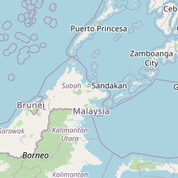

Leaflet | © OpenStreetMap contributors
Time
Current local time in Ramain:
Time: 23:04 PST
Date: 2025-03-21
Sunrise and Sunset
| Date | Sunrise | Sunset |
|---|---|---|
| 2025-03-21 (Today) | 05:45 | 17:54 |
| 2025-03-22 (Tomorrow) | 05:44 | 17:54 |
| 2025-03-23 | 05:44 | 17:54 |
| 2025-03-24 | 05:43 | 17:54 |
| 2025-03-25 | 05:43 | 17:54 |
| 2025-03-26 | 05:42 | 17:54 |
| 2025-03-27 | 05:42 | 17:53 |