
Cities close to Perez
Cities, towns and suburbs near Perez. Agdangan: 35 kilometers (22 miles), Kalayaan: 42 kilometers (26 miles), Lucena: 44 kilometers (28 miles).
| Cities / towns / suburbs around Perez | Kilometers | Miles |
|---|---|---|
| How far is Agdangan from Perez | 35 | 22 |
| How far is Kalayaan from Perez | 42 | 26 |
| How far is Lucena from Perez | 44 | 28 |
| How far is Luisiana from Perez | 45 | 28 |
| How far is Cavinti from Perez | 45 | 28 |
| How far is Majayjay from Perez | 49 | 31 |
| How far is Santa Elena from Perez | 49 | 31 |
| How far is Paete from Perez | 51 | 32 |
| How far is Pagsanjan from Perez | 52 | 32 |
| How far is Pakil from Perez | 53 | 33 |
Closest airport to Perez
| Airport | Kilometers | Miles |
|---|---|---|
| Ninoy Aquino International Airport (MNL) | 103.8 | 64.5 |
| Naga Airport (WNP) | 160.3 | 99.6 |
| Dr. Juan C. Angara Airport (BQA) | 176.9 | 109.9 |
Distance from Perez to other municipalities
| Municipality | Kilometers | Miles |
|---|---|---|
| How far is Bacolod City from Perez | 408 | 253 |
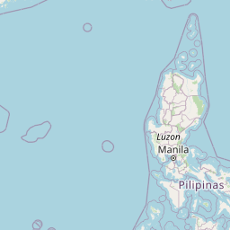
Location
Coordinates:
Latitude: 14°11′40″N
Longitude: 121°55′34″E
Map


Leaflet | © OpenStreetMap contributors
Time
Current local time in Perez:
Time: 22:58 PST
Date: 2025-03-21
Sunrise and Sunset
| Date | Sunrise | Sunset |
|---|---|---|
| 2025-03-21 (Today) | 05:54 | 18:04 |
| 2025-03-22 (Tomorrow) | 05:53 | 18:04 |
| 2025-03-23 | 05:53 | 18:04 |
| 2025-03-24 | 05:52 | 18:04 |
| 2025-03-25 | 05:51 | 18:04 |
| 2025-03-26 | 05:51 | 18:04 |
| 2025-03-27 | 05:50 | 18:04 |