
Cities close to Alangalang
Cities, towns and suburbs near Alangalang. San Miguel: 7 kilometers (4 miles), Jaro: 7 kilometers (5 miles), Santa Fe: 8 kilometers (5 miles).
| Cities / towns / suburbs around Alangalang | Kilometers | Miles |
|---|---|---|
| How far is San Miguel from Alangalang | 7 | 4 |
| How far is Jaro from Alangalang | 7 | 5 |
| How far is Santa Fe from Alangalang | 8 | 5 |
| How far is Pastrana from Alangalang | 9 | 5 |
| How far is Tunga from Alangalang | 11 | 7 |
| How far is Palo from Alangalang | 17 | 10 |
| How far is Dagami from Alangalang | 17 | 11 |
| How far is Barugo from Alangalang | 18 | 11 |
| How far is Tacloban from Alangalang | 18 | 11 |
| How far is Carigara from Alangalang | 21 | 13 |
Closest airport to Alangalang
| Airport | Kilometers | Miles |
|---|---|---|
| Daniel Z. Romualdez Airport (TAC) | 19.9 | 12.4 |
| Calbayog Airport (CYP) | 101.9 | 63.3 |
| Mactan–Cebu International Airport (CEB) | 137.9 | 85.7 |
Location
Coordinates:
Latitude: 11°12′21″N
Longitude: 124°50′48″E
Map
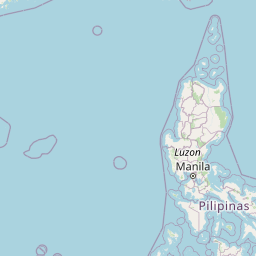

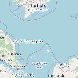


Leaflet | © OpenStreetMap contributors
Time
Current local time in Alangalang:
Time: 07:52 PST
Date: 2025-02-18
Sunrise and Sunset
| Date | Sunrise | Sunset |
|---|---|---|
| 2025-02-18 (Today) | 05:59 | 17:49 |
| 2025-02-19 (Tomorrow) | 05:58 | 17:50 |
| 2025-02-20 | 05:58 | 17:50 |
| 2025-02-21 | 05:58 | 17:50 |
| 2025-02-22 | 05:57 | 17:50 |
| 2025-02-23 | 05:57 | 17:50 |
| 2025-02-24 | 05:56 | 17:50 |