
Cities close to Inguilpata
Cities, towns and suburbs near Inguilpata. Lonya Chico: 1 kilometers (1 miles), Colcamar: 7 kilometers (4 miles), Luya: 9 kilometers (5 miles).
| Cities / towns / suburbs around Inguilpata | Kilometers | Miles |
|---|---|---|
| How far is Lonya Chico from Inguilpata | 1 | 1 |
| How far is Colcamar from Inguilpata | 7 | 4 |
| How far is Luya from Inguilpata | 9 | 5 |
| How far is Chachapoyas from Inguilpata | 10 | 6 |
| How far is Levanto from Inguilpata | 10 | 6 |
| How far is Lamud from Inguilpata | 12 | 7 |
| How far is Huancas from Inguilpata | 13 | 8 |
| How far is Maino from Inguilpata | 14 | 8 |
| How far is Olto from Inguilpata | 15 | 10 |
| How far is Tingo from Inguilpata | 15 | 10 |
Closest airport to Inguilpata
| Airport | Kilometers | Miles |
|---|---|---|
| Shumba Airport (JAE) | 115.7 | 71.9 |
| Mayor General FAP Armando Revoredo Iglesias Airport (CJA) | 116.0 | 72.1 |
| Tarapoto Airport (TPP) | 177.8 | 110.5 |
Location
Coordinates:
Latitude: 6°14′26″S
Longitude: 77°57′25″W
Map
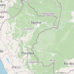


Leaflet | © OpenStreetMap contributors
Time
Current local time in Inguilpata:
Time: 22:19 -05
Date: 2025-03-16
Sunrise and Sunset
| Date | Sunrise | Sunset |
|---|---|---|
| 2025-03-16 (Today) | 06:15 | 18:25 |
| 2025-03-17 (Tomorrow) | 06:15 | 18:24 |
| 2025-03-18 | 06:15 | 18:24 |
| 2025-03-19 | 06:14 | 18:23 |
| 2025-03-20 | 06:14 | 18:23 |
| 2025-03-21 | 06:14 | 18:23 |
| 2025-03-22 | 06:14 | 18:22 |