
Cities close to Chongoyape
Cities, towns and suburbs near Chongoyape. Tocmoche: 26 kilometers (16 miles), Nueva Arica: 26 kilometers (16 miles), Miracosta: 29 kilometers (18 miles).
| Cities / towns / suburbs around Chongoyape | Kilometers | Miles |
|---|---|---|
| How far is Tocmoche from Chongoyape | 26 | 16 |
| How far is Nueva Arica from Chongoyape | 26 | 16 |
| How far is Miracosta from Chongoyape | 29 | 18 |
| How far is Licupis from Chongoyape | 29 | 18 |
| How far is Llama from Chongoyape | 33 | 20 |
| How far is Sexi from Chongoyape | 38 | 24 |
| How far is Manuel Antonio Mesones Muro from Chongoyape | 39 | 24 |
| How far is Nanchoc from Chongoyape | 39 | 24 |
| How far is La Florida from Chongoyape | 39 | 24 |
| How far is Catache from Chongoyape | 40 | 25 |
Closest airport to Chongoyape
| Airport | Kilometers | Miles |
|---|---|---|
| Chiclayo International Airport (CIX) | 51.2 | 31.8 |
| Mayor General FAP Armando Revoredo Iglesias Airport (CJA) | 113.9 | 70.8 |
| Shumba Airport (JAE) | 135.1 | 83.9 |
Distance from Chongoyape to other municipalities
| Municipality | Kilometers | Miles |
|---|---|---|
| How far is Moche from Chongoyape | 175 | 109 |
Location
Coordinates:
Latitude: 6°38′26″S
Longitude: 79°23′21″W
Map
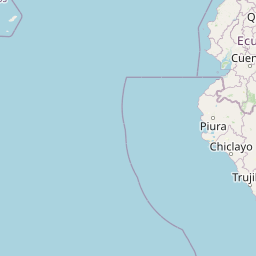


Leaflet | © OpenStreetMap contributors
Time
Current local time in Chongoyape:
Time: 09:35 -05
Date: 2025-03-21
Sunrise and Sunset
| Date | Sunrise | Sunset |
|---|---|---|
| 2025-03-21 (Today) | 06:20 | 18:28 |
| 2025-03-22 (Tomorrow) | 06:20 | 18:28 |
| 2025-03-23 | 06:20 | 18:27 |
| 2025-03-24 | 06:20 | 18:27 |
| 2025-03-25 | 06:19 | 18:26 |
| 2025-03-26 | 06:19 | 18:26 |
| 2025-03-27 | 06:19 | 18:25 |