
Cities close to Varhaug
Cities, towns and suburbs near Varhaug. Bryne: 13 kilometers (8 miles), Kleppe: 17 kilometers (11 miles), Ålgård: 20 kilometers (12 miles).
| Cities / towns / suburbs around Varhaug | Kilometers | Miles |
|---|---|---|
| How far is Bryne from Varhaug | 13 | 8 |
| How far is Kleppe from Varhaug | 17 | 11 |
| How far is Ålgård from Varhaug | 20 | 12 |
| How far is Vikeså from Varhaug | 25 | 16 |
| How far is Sandnes from Varhaug | 26 | 16 |
| How far is Egersund from Varhaug | 27 | 17 |
| How far is Sola from Varhaug | 30 | 19 |
| How far is Stavanger from Varhaug | 39 | 24 |
| How far is Forsand from Varhaug | 41 | 25 |
| How far is Randaberg from Varhaug | 42 | 26 |
Closest airport to Varhaug
| Airport | Kilometers | Miles |
|---|---|---|
| Stavanger Airport, Sola (SVG) | 28.8 | 17.9 |
| Haugesund Airport, Karmøy (HAU) | 84.9 | 52.8 |
| Stord Airport, Sørstokken (SRP) | 131.9 | 82.0 |
Location
Coordinates:
Latitude: 58°37′5″N
Longitude: 5°39′25″E
Map
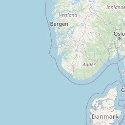


Leaflet | © OpenStreetMap contributors
Time
Current local time in Varhaug:
Time: 15:09 CET
Date: 2025-03-21
Sunrise and Sunset
| Date | Sunrise | Sunset |
|---|---|---|
| 2025-03-21 (Today) | 06:33 | 18:55 |
| 2025-03-22 (Tomorrow) | 06:30 | 18:58 |
| 2025-03-23 | 06:27 | 19:00 |
| 2025-03-24 | 06:24 | 19:02 |
| 2025-03-25 | 06:21 | 19:04 |
| 2025-03-26 | 06:18 | 19:07 |
| 2025-03-27 | 06:15 | 19:09 |