
Cities close to Gaya
Cities, towns and suburbs near Gaya. Dosso: 132 kilometers (82 miles), Birnin Gaouré: 145 kilometers (90 miles), Say: 179 kilometers (111 miles).
| Cities / towns / suburbs around Gaya | Kilometers | Miles |
|---|---|---|
| How far is Dosso from Gaya | 132 | 82 |
| How far is Birnin Gaouré from Gaya | 145 | 90 |
| How far is Say from Gaya | 179 | 111 |
| How far is Loga from Gaya | 194 | 120 |
| How far is Kollo from Gaya | 199 | 123 |
| How far is Dogondoutchi from Gaya | 205 | 127 |
| How far is Niamey from Gaya | 232 | 144 |
| How far is Filingué from Gaya | 275 | 171 |
| How far is Ouallam from Gaya | 308 | 191 |
| How far is Tillabéri from Gaya | 337 | 209 |
Closest airport to Gaya
| Airport | Kilometers | Miles |
|---|---|---|
| Sadiq Abubakar III International Airport (SKO) | 223.0 | 138.6 |
| Diori Hamani International Airport (NIM) | 224.7 | 139.6 |
| Ilorin International Airport (ILR) | 400.1 | 248.6 |
Distance from Gaya to other municipalities
| Municipality | Kilometers | Miles |
|---|---|---|
| How far is Diffa from Gaya | 1 007 | 626 |
| How far is Agadez from Gaya | 748 | 465 |
| How far is Tessaoua from Gaya | 534 | 332 |
| How far is Magaria from Gaya | 606 | 376 |
| How far is Madaoua from Gaya | 365 | 227 |
Location
Coordinates:
Latitude: 11°53′3″N
Longitude: 3°26′57″E
Map
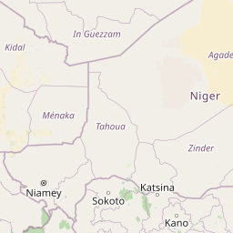


Leaflet | © OpenStreetMap contributors
Time
Current local time in Gaya:
Time: 23:50 WAT
Date: 2025-02-20
Sunrise and Sunset
| Date | Sunrise | Sunset |
|---|---|---|
| 2025-02-20 (Today) | 07:04 | 18:55 |
| 2025-02-21 (Tomorrow) | 07:03 | 18:55 |
| 2025-02-22 | 07:03 | 18:55 |
| 2025-02-23 | 07:03 | 18:55 |
| 2025-02-24 | 07:02 | 18:56 |
| 2025-02-25 | 07:02 | 18:56 |
| 2025-02-26 | 07:01 | 18:56 |