
Cities close to Teapa
Cities, towns and suburbs near Teapa. Tacotalpa: 14 kilometers (9 miles), Jalapa: 24 kilometers (15 miles), Ostuacán: 44 kilometers (27 miles).
| Cities / towns / suburbs around Teapa | Kilometers | Miles |
|---|---|---|
| How far is Tacotalpa from Teapa | 14 | 9 |
| How far is Jalapa from Teapa | 24 | 15 |
| How far is Ostuacán from Teapa | 44 | 27 |
| How far is Macuspana from Teapa | 44 | 28 |
| How far is Villahermosa from Teapa | 49 | 30 |
| How far is Huimanguillo from Teapa | 56 | 35 |
| How far is Bochil from Teapa | 62 | 38 |
| How far is Cunduacán from Teapa | 62 | 38 |
| How far is Salto de Agua from Teapa | 65 | 40 |
| How far is Nacajuca from Teapa | 69 | 43 |
Closest airport to Teapa
| Airport | Kilometers | Miles |
|---|---|---|
| Villahermosa International Airport (VSA) | 51.8 | 32.2 |
| Palenque International Airport (PQM) | 99.4 | 61.8 |
| Tuxtla Gutiérrez International Airport (TGZ) | 110.0 | 68.4 |
Location
Coordinates:
Latitude: 17°32′58″N
Longitude: 92°57′7″W
Map
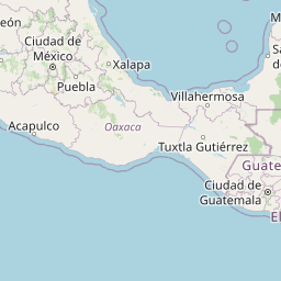


Leaflet | © OpenStreetMap contributors
Time
Current local time in Teapa:
Time: 07:17 CST
Date: 2025-03-21
Sunrise and Sunset
| Date | Sunrise | Sunset |
|---|---|---|
| 2025-03-21 (Today) | 06:13 | 18:24 |
| 2025-03-22 (Tomorrow) | 06:12 | 18:24 |
| 2025-03-23 | 06:11 | 18:24 |
| 2025-03-24 | 06:11 | 18:24 |
| 2025-03-25 | 06:10 | 18:24 |
| 2025-03-26 | 06:09 | 18:25 |
| 2025-03-27 | 06:08 | 18:25 |