
Cities close to Quiroga
Cities, towns and suburbs near Quiroga. Lagunillas: 16 kilometers (10 miles), Huiramba: 16 kilometers (10 miles), Coeneo de la Libertad: 19 kilometers (12 miles).
| Cities / towns / suburbs around Quiroga | Kilometers | Miles |
|---|---|---|
| How far is Lagunillas from Quiroga | 16 | 10 |
| How far is Huiramba from Quiroga | 16 | 10 |
| How far is Coeneo de la Libertad from Quiroga | 19 | 12 |
| How far is Pátzcuaro from Quiroga | 19 | 12 |
| How far is Erongarícuaro from Quiroga | 22 | 14 |
| How far is Huaniqueo de Morales from Quiroga | 26 | 16 |
| How far is Acuítzio del Canje from Quiroga | 27 | 17 |
| How far is Santa Clara del Cobre from Quiroga | 31 | 20 |
| How far is Zacapú from Quiroga | 33 | 20 |
| How far is Chucándiro from Quiroga | 33 | 20 |
Closest airport to Quiroga
| Airport | Kilometers | Miles |
|---|---|---|
| Morelia International Airport (MLM) | 56.1 | 34.8 |
| Uruapan International Airport (UPN) | 61.9 | 38.4 |
| Captain Rogelio Castillo National Airport (CYW) | 118.4 | 73.6 |
Location
Coordinates:
Latitude: 19°39′56″N
Longitude: 101°31′22″W
Map
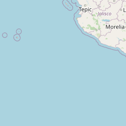


Leaflet | © OpenStreetMap contributors
Time
Current local time in Quiroga:
Time: 08:09 CST
Date: 2025-03-21
Sunrise and Sunset
| Date | Sunrise | Sunset |
|---|---|---|
| 2025-03-21 (Today) | 06:47 | 18:58 |
| 2025-03-22 (Tomorrow) | 06:46 | 18:58 |
| 2025-03-23 | 06:45 | 18:59 |
| 2025-03-24 | 06:45 | 18:59 |
| 2025-03-25 | 06:44 | 18:59 |
| 2025-03-26 | 06:43 | 18:59 |
| 2025-03-27 | 06:42 | 19:00 |