
Cities close to Chuka
Cities, towns and suburbs near Chuka. Kathwana: 25 kilometers (15 miles), Embu: 31 kilometers (19 miles), Meru: 42 kilometers (26 miles).
| Cities / towns / suburbs around Chuka | Kilometers | Miles |
|---|---|---|
| How far is Kathwana from Chuka | 25 | 15 |
| How far is Embu from Chuka | 31 | 19 |
| How far is Meru from Chuka | 42 | 26 |
| How far is Kerugoya from Chuka | 45 | 28 |
| How far is Murang’a from Chuka | 70 | 43 |
| How far is Isiolo from Chuka | 77 | 48 |
| How far is Nyeri from Chuka | 78 | 49 |
| How far is Kitui from Chuka | 122 | 76 |
| How far is Kiambu from Chuka | 130 | 81 |
| How far is Machakos from Chuka | 139 | 86 |
Closest airport to Chuka
| Airport | Kilometers | Miles |
|---|---|---|
| Nanyuki Airport (NYK) | 73.8 | 45.8 |
| Mulika Lodge Airport (JJM) | 82.6 | 51.3 |
| Jomo Kenyatta International Airport (NBO) | 135.8 | 84.4 |
Distance from Chuka to other municipalities
| Municipality | Kilometers | Miles |
|---|---|---|
| How far is Meru from Chuka | 42 | 26 |
| How far is Nanyuki from Chuka | 75 | 46 |
| How far is Murang’a from Chuka | 70 | 43 |
| How far is Kisii from Chuka | 322 | 200 |
| How far is Mombasa from Chuka | 471 | 292 |
| How far is Wote from Chuka | 161 | 100 |
| How far is Nyahururu from Chuka | 148 | 92 |
| How far is Garissa from Chuka | 223 | 138 |
| How far is Wote from Chuka | 161 | 100 |
| How far is Kilifi from Chuka | 441 | 274 |
Location
Coordinates:
Latitude: 0°19′59″S
Longitude: 37°38′45″E
Map
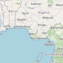


Leaflet | © OpenStreetMap contributors
Time
Current local time in Chuka:
Time: 15:54 EAT
Date: 2025-03-21
Sunrise and Sunset
| Date | Sunrise | Sunset |
|---|---|---|
| 2025-03-21 (Today) | 06:32 | 18:40 |
| 2025-03-22 (Tomorrow) | 06:31 | 18:40 |
| 2025-03-23 | 06:31 | 18:40 |
| 2025-03-24 | 06:31 | 18:40 |
| 2025-03-25 | 06:30 | 18:39 |
| 2025-03-26 | 06:30 | 18:39 |
| 2025-03-27 | 06:30 | 18:39 |