
Cities close to Şakhrah
Cities, towns and suburbs near Şakhrah. ‘Ajlūn: 9 kilometers (6 miles), ‘Irjān: 11 kilometers (7 miles), Jarash: 11 kilometers (7 miles).
| Cities / towns / suburbs around Şakhrah | Kilometers | Miles |
|---|---|---|
| How far is ‘Ajlūn from Şakhrah | 9 | 6 |
| How far is ‘Irjān from Şakhrah | 11 | 7 |
| How far is Jarash from Şakhrah | 11 | 7 |
| How far is Al Mazār ash Shamālī from Şakhrah | 12 | 7 |
| How far is Al Ḩişn from Şakhrah | 13 | 8 |
| How far is Kufrinjah from Şakhrah | 16 | 10 |
| How far is Burmā from Şakhrah | 18 | 11 |
| How far is Dayr Abū Sa‘īd from Şakhrah | 20 | 13 |
| How far is Irbid from Şakhrah | 21 | 13 |
| How far is Al Maşţabah from Şakhrah | 21 | 13 |
Closest airport to Şakhrah
| Airport | Kilometers | Miles |
|---|---|---|
| Amman Civil Airport (ADJ) | 46.5 | 28.9 |
| Rosh Pina Airport (RPN) | 72.5 | 45.1 |
| Queen Alia International Airport (AMM) | 73.5 | 45.7 |
Location
Coordinates:
Latitude: 32°22′15″N
Longitude: 35°50′33″E
Map
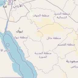


Leaflet | © OpenStreetMap contributors
Time
Current local time in Şakhrah:
Time: 17:28 +03
Date: 2025-03-21
Sunrise and Sunset
| Date | Sunrise | Sunset |
|---|---|---|
| 2025-03-21 (Today) | 06:37 | 18:49 |
| 2025-03-22 (Tomorrow) | 06:36 | 18:50 |
| 2025-03-23 | 06:34 | 18:51 |
| 2025-03-24 | 06:33 | 18:52 |
| 2025-03-25 | 06:32 | 18:52 |
| 2025-03-26 | 06:30 | 18:53 |
| 2025-03-27 | 06:29 | 18:54 |