
Cities close to Sengge
Cities, towns and suburbs near Sengge. Ubrub: 32 kilometers (20 miles), Banda: 35 kilometers (22 miles), Waris: 39 kilometers (24 miles).
| Cities / towns / suburbs around Sengge | Kilometers | Miles |
|---|---|---|
| How far is Ubrub from Sengge | 32 | 20 |
| How far is Banda from Sengge | 35 | 22 |
| How far is Waris from Sengge | 39 | 24 |
| How far is Arso from Sengge | 61 | 38 |
| How far is Abepura from Sengge | 96 | 60 |
| How far is Jayapura from Sengge | 102 | 63 |
| How far is Sentani from Sengge | 102 | 63 |
| How far is Sawoi from Sengge | 104 | 64 |
| How far is Depapre from Sengge | 116 | 72 |
| How far is Genyem from Sengge | 119 | 74 |
Closest airport to Sengge
| Airport | Kilometers | Miles |
|---|---|---|
| Senggeh Airport (SEH) | 4.9 | 3.1 |
| Dortheys Hiyo Eluay International Airport (DJJ) | 101.1 | 62.8 |
| Vanimo Airport (VAI) | 102.0 | 63.4 |
Location
Coordinates:
Latitude: 3°26′51″S
Longitude: 140°46′30″E
Map
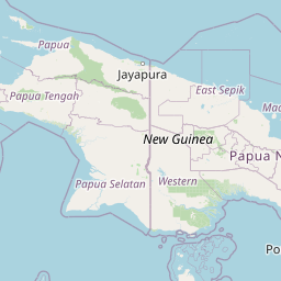

Leaflet | © OpenStreetMap contributors
Time
Current local time in Sengge:
Time: 23:50 WIT
Date: 2025-03-21
Sunrise and Sunset
| Date | Sunrise | Sunset |
|---|---|---|
| 2025-03-21 (Today) | 05:39 | 17:48 |
| 2025-03-22 (Tomorrow) | 05:39 | 17:48 |
| 2025-03-23 | 05:39 | 17:47 |
| 2025-03-24 | 05:39 | 17:47 |
| 2025-03-25 | 05:38 | 17:46 |
| 2025-03-26 | 05:38 | 17:46 |
| 2025-03-27 | 05:38 | 17:46 |