
Cities close to Bajo
Cities, towns and suburbs near Bajo. Belopa: 6 kilometers (4 miles), Lempokasi: 11 kilometers (7 miles), Padangsappa: 16 kilometers (10 miles).
| Cities / towns / suburbs around Bajo | Kilometers | Miles |
|---|---|---|
| How far is Belopa from Bajo | 6 | 4 |
| How far is Lempokasi from Bajo | 11 | 7 |
| How far is Padangsappa from Bajo | 16 | 10 |
| How far is Larompong from Bajo | 17 | 10 |
| How far is Beuma from Bajo | 34 | 21 |
| How far is Siwa from Bajo | 38 | 23 |
| How far is Beringinjaya from Bajo | 43 | 27 |
| How far is Batuputih from Bajo | 49 | 30 |
| How far is Baraka from Bajo | 51 | 31 |
| How far is Getengan from Bajo | 52 | 32 |
Closest airport to Bajo
| Airport | Kilometers | Miles |
|---|---|---|
| Bua Airport (LLO) | 33.7 | 21.0 |
| Pongtiku Airport (TTR) | 65.8 | 40.9 |
| Andi Jemma Airport (MXB) | 91.4 | 56.8 |
Location
Coordinates:
Latitude: 3°22′43″S
Longitude: 120°18′36″E
Map
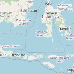
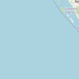

Leaflet | © OpenStreetMap contributors
Time
Current local time in Bajo:
Time: 22:09 WITA
Date: 2025-03-21
Sunrise and Sunset
| Date | Sunrise | Sunset |
|---|---|---|
| 2025-03-21 (Today) | 06:01 | 18:10 |
| 2025-03-22 (Tomorrow) | 06:01 | 18:09 |
| 2025-03-23 | 06:01 | 18:09 |
| 2025-03-24 | 06:00 | 18:09 |
| 2025-03-25 | 06:00 | 18:08 |
| 2025-03-26 | 06:00 | 18:08 |
| 2025-03-27 | 06:00 | 18:07 |