
Cities close to Limbdi
Cities, towns and suburbs near Limbdi. Valsād: 246 kilometers (153 miles), Daman: 261 kilometers (162 miles), Silvassa: 283 kilometers (176 miles).
| Cities / towns / suburbs around Limbdi | Kilometers | Miles |
|---|---|---|
| How far is Valsād from Limbdi | 246 | 153 |
| How far is Daman from Limbdi | 261 | 162 |
| How far is Silvassa from Limbdi | 283 | 176 |
| How far is Nashik from Limbdi | 352 | 218 |
| How far is Neemuch from Limbdi | 377 | 234 |
| How far is Mumbai from Limbdi | 404 | 251 |
| How far is Aurangabad from Limbdi | 473 | 294 |
| How far is Beed from Limbdi | 571 | 355 |
| How far is Bhopal from Limbdi | 578 | 359 |
| How far is Jaipur from Limbdi | 629 | 391 |
Closest airport to Limbdi
| Airport | Kilometers | Miles |
|---|---|---|
| Bhavnagar Airport (BHU) | 98.4 | 61.1 |
| Sardar Vallabhbhai Patel International Airport (AMD) | 102.0 | 63.4 |
| Rajkot Airport (RAJ) | 109.9 | 68.3 |
Location
Coordinates:
Latitude: 22°33′54″N
Longitude: 71°48′38″E
Map

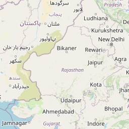


Leaflet | © OpenStreetMap contributors
Time
Current local time in Limbdi:
Time: 21:22 IST
Date: 2025-02-15
Sunrise and Sunset
| Date | Sunrise | Sunset |
|---|---|---|
| 2025-02-15 (Today) | 07:13 | 18:40 |
| 2025-02-16 (Tomorrow) | 07:12 | 18:41 |
| 2025-02-17 | 07:11 | 18:41 |
| 2025-02-18 | 07:11 | 18:42 |
| 2025-02-19 | 07:10 | 18:42 |
| 2025-02-20 | 07:09 | 18:43 |
| 2025-02-21 | 07:09 | 18:43 |