
Cities close to Jhā-Jhā
Cities, towns and suburbs near Jhā-Jhā. Ranchi: 192 kilometers (120 miles), Jalpāiguri: 306 kilometers (190 miles), Kolkata: 318 kilometers (198 miles).
| Cities / towns / suburbs around Jhā-Jhā | Kilometers | Miles |
|---|---|---|
| How far is Ranchi from Jhā-Jhā | 192 | 120 |
| How far is Jalpāiguri from Jhā-Jhā | 306 | 190 |
| How far is Kolkata from Jhā-Jhā | 318 | 198 |
| How far is Gangtok from Jhā-Jhā | 361 | 224 |
| How far is Bhubaneshwar from Jhā-Jhā | 503 | 313 |
| How far is Agartala from Jhā-Jhā | 507 | 315 |
| How far is Mushalpur from Jhā-Jhā | 544 | 338 |
| How far is Shillong from Jhā-Jhā | 561 | 349 |
| How far is Dispur from Jhā-Jhā | 565 | 351 |
| How far is Lucknow from Jhā-Jhā | 593 | 368 |
Closest airport to Jhā-Jhā
| Airport | Kilometers | Miles |
|---|---|---|
| Gaya Airport (GAY) | 144.4 | 89.7 |
| Kazi Nazrul Islam Airport (RDP) | 155.1 | 96.4 |
| Jay Prakash Narayan Airport (PAT) | 158.9 | 98.7 |
Location
Coordinates:
Latitude: 24°46′15″N
Longitude: 86°22′43″E
Map

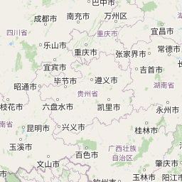


Leaflet | © OpenStreetMap contributors
Time
Current local time in Jhā-Jhā:
Time: 19:16 IST
Date: 2025-03-21
Sunrise and Sunset
| Date | Sunrise | Sunset |
|---|---|---|
| 2025-03-21 (Today) | 05:46 | 17:57 |
| 2025-03-22 (Tomorrow) | 05:45 | 17:57 |
| 2025-03-23 | 05:44 | 17:58 |
| 2025-03-24 | 05:43 | 17:58 |
| 2025-03-25 | 05:42 | 17:58 |
| 2025-03-26 | 05:40 | 17:59 |
| 2025-03-27 | 05:39 | 17:59 |