
Cities close to San Miguel
Cities, towns and suburbs near San Miguel. San Francisco: 26 kilometers (16 miles), Usulután: 32 kilometers (20 miles), La Unión: 40 kilometers (25 miles).
| Cities / towns / suburbs around San Miguel | Kilometers | Miles |
|---|---|---|
| How far is San Francisco from San Miguel | 26 | 16 |
| How far is Usulután from San Miguel | 32 | 20 |
| How far is La Unión from San Miguel | 40 | 25 |
| How far is Sensuntepeque from San Miguel | 65 | 40 |
| How far is San Vicente from San Miguel | 69 | 43 |
| How far is Zacatecoluca from San Miguel | 74 | 46 |
| How far is Cojutepeque from San Miguel | 85 | 53 |
| How far is Chalatenango from San Miguel | 101 | 63 |
| How far is San Salvador from San Miguel | 111 | 69 |
| How far is Santa Tecla from San Miguel | 120 | 75 |
Closest airport to San Miguel
| Airport | Kilometers | Miles |
|---|---|---|
| El Salvador International Airport (SAL) | 94.6 | 58.8 |
| Toncontín International Airport (TGU) | 122.7 | 76.2 |
| Ramón Villeda Morales International Airport (SAP) | 221.0 | 137.3 |
Distance from San Miguel to other municipalities
Location
Coordinates:
Latitude: 13°28′59″N
Longitude: 88°10′59″W
Map
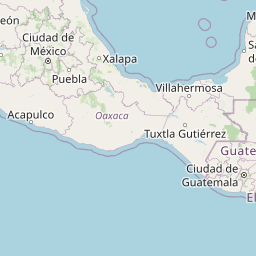


Leaflet | © OpenStreetMap contributors
Time
Current local time in San Miguel:
Time: 14:45 CST
Date: 2025-02-18
Sunrise and Sunset
| Date | Sunrise | Sunset |
|---|---|---|
| 2025-02-18 (Today) | 06:12 | 18:00 |
| 2025-02-19 (Tomorrow) | 06:12 | 18:00 |
| 2025-02-20 | 06:12 | 18:00 |
| 2025-02-21 | 06:11 | 18:00 |
| 2025-02-22 | 06:11 | 18:01 |
| 2025-02-23 | 06:10 | 18:01 |
| 2025-02-24 | 06:10 | 18:01 |