
Cities close to Ibshawāy
Cities, towns and suburbs near Ibshawāy. Banī Suwayf: 51 kilometers (32 miles), Giza: 89 kilometers (55 miles), Cairo: 96 kilometers (59 miles).
| Cities / towns / suburbs around Ibshawāy | Kilometers | Miles |
|---|---|---|
| How far is Banī Suwayf from Ibshawāy | 51 | 32 |
| How far is Giza from Ibshawāy | 89 | 55 |
| How far is Cairo from Ibshawāy | 96 | 59 |
| How far is Banhā from Ibshawāy | 131 | 82 |
| How far is Beheira from Ibshawāy | 133 | 82 |
| How far is Shibīn al Kawm from Ibshawāy | 137 | 85 |
| How far is Al Minyā from Ibshawāy | 139 | 86 |
| How far is Zagazig from Ibshawāy | 158 | 98 |
| How far is Tanda from Ibshawāy | 162 | 101 |
| How far is Damanhūr from Ibshawāy | 187 | 117 |
Closest airport to Ibshawāy
| Airport | Kilometers | Miles |
|---|---|---|
| Cairo International Airport (CAI) | 110.1 | 68.4 |
| Borg El Arab Airport (HBE) | 197.8 | 122.9 |
| El Nouzha Airport (ALY) | 215.1 | 133.7 |
Location
Coordinates:
Latitude: 29°21′28″N
Longitude: 30°40′53″E
Map
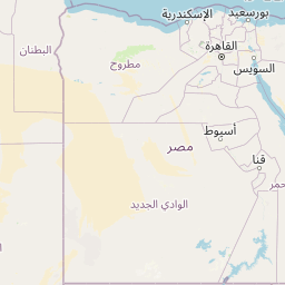


Leaflet | © OpenStreetMap contributors
Time
Current local time in Ibshawāy:
Time: 16:28 EET
Date: 2025-03-21
Sunrise and Sunset
| Date | Sunrise | Sunset |
|---|---|---|
| 2025-03-21 (Today) | 05:58 | 18:10 |
| 2025-03-22 (Tomorrow) | 05:57 | 18:10 |
| 2025-03-23 | 05:56 | 18:11 |
| 2025-03-24 | 05:54 | 18:12 |
| 2025-03-25 | 05:53 | 18:12 |
| 2025-03-26 | 05:52 | 18:13 |
| 2025-03-27 | 05:51 | 18:13 |