
Cities close to Gaolan Chengguanzhen
Cities, towns and suburbs near Gaolan Chengguanzhen. Baiyin: 31 kilometers (19 miles), Renminlu: 31 kilometers (19 miles), Lanzhou: 32 kilometers (20 miles).
Closest airport to Gaolan Chengguanzhen
| Airport | Kilometers | Miles |
|---|---|---|
| Lanzhou Zhongchuan International Airport (LHW) | 35.4 | 22.0 |
| Xining Caojiabao International Airport (XNN) | 171.7 | 106.7 |
| Zhongwei Shapotou Airport (ZHY) | 174.8 | 108.6 |
Location
Coordinates:
Latitude: 36°20′4″N
Longitude: 103°56′44″E
Map
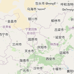

Leaflet | © OpenStreetMap contributors
Time
Current local time in Gaolan Chengguanzhen:
Time: 12:18 CST
Date: 2025-02-19
Sunrise and Sunset
| Date | Sunrise | Sunset |
|---|---|---|
| 2025-02-19 (Today) | 07:45 | 18:50 |
| 2025-02-20 (Tomorrow) | 07:44 | 18:51 |
| 2025-02-21 | 07:43 | 18:52 |
| 2025-02-22 | 07:42 | 18:53 |
| 2025-02-23 | 07:40 | 18:54 |
| 2025-02-24 | 07:39 | 18:55 |
| 2025-02-25 | 07:38 | 18:56 |