
Cities close to Awat
Cities, towns and suburbs near Awat. Aksu: 61 kilometers (38 miles), Wensu: 71 kilometers (44 miles), Aral: 76 kilometers (47 miles).
| Cities / towns / suburbs around Awat | Kilometers | Miles |
|---|---|---|
| How far is Aksu from Awat | 61 | 38 |
| How far is Wensu from Awat | 71 | 44 |
| How far is Aral from Awat | 76 | 47 |
| How far is Kalpin from Awat | 112 | 69 |
| How far is Wushi from Awat | 113 | 70 |
| How far is Akqi from Awat | 166 | 103 |
| How far is Baicheng from Awat | 177 | 110 |
| How far is Xinhe from Awat | 213 | 132 |
| How far is Xayar from Awat | 214 | 133 |
| How far is Kuqa from Awat | 246 | 153 |
Closest airport to Awat
| Airport | Kilometers | Miles |
|---|---|---|
| Aksu Onsu Airport (AKU) | 69.9 | 43.4 |
| Kuqa Qiuci Airport (KCA) | 249.3 | 154.9 |
| Issyk-Kul International Airport (IKU) | 374.4 | 232.6 |
Location
Coordinates:
Latitude: 40°38′18″N
Longitude: 80°22′46″E
Map
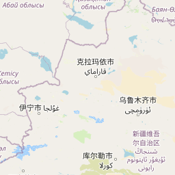
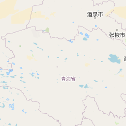

Leaflet | © OpenStreetMap contributors
Time
Current local time in Awat:
Time: 17:19 CST
Date: 2025-03-20
Sunrise and Sunset
| Date | Sunrise | Sunset |
|---|---|---|
| 2025-03-20 (Today) | 08:40 | 20:51 |
| 2025-03-21 (Tomorrow) | 08:38 | 20:52 |
| 2025-03-22 | 08:36 | 20:53 |
| 2025-03-23 | 08:35 | 20:54 |
| 2025-03-24 | 08:33 | 20:55 |
| 2025-03-25 | 08:31 | 20:56 |
| 2025-03-26 | 08:30 | 20:57 |