
Cities close to Teknāf
Cities, towns and suburbs near Teknāf. Barisāl: 286 kilometers (178 miles), Bagerhat: 327 kilometers (203 miles), Khulna: 356 kilometers (221 miles).
| Cities / towns / suburbs around Teknāf | Kilometers | Miles |
|---|---|---|
| How far is Barisāl from Teknāf | 286 | 178 |
| How far is Bagerhat from Teknāf | 327 | 203 |
| How far is Khulna from Teknāf | 356 | 221 |
| How far is Dhaka from Teknāf | 372 | 231 |
| How far is Magura from Teknāf | 417 | 259 |
| How far is Sylhet from Teknāf | 451 | 281 |
| How far is Chhātak from Teknāf | 469 | 292 |
| How far is Mymensingh from Teknāf | 475 | 295 |
| How far is Netrakona from Teknāf | 476 | 295 |
| How far is Purbadhala from Teknāf | 486 | 302 |
Closest airport to Teknāf
| Airport | Kilometers | Miles |
|---|---|---|
| Cox's Bazar Airport (CXB) | 74.6 | 46.4 |
| Sittwe Airport (AKY) | 100.6 | 62.5 |
| Shah Amanat International Airport (CGP) | 162.8 | 101.2 |
Location
Coordinates:
Latitude: 20°51′29″N
Longitude: 92°17′51″E
Map


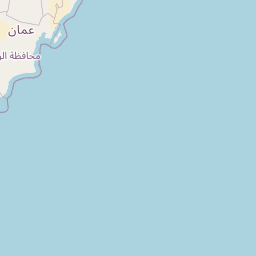

Leaflet | © OpenStreetMap contributors
Time
Current local time in Teknāf:
Time: 20:57 +06
Date: 2025-03-21
Sunrise and Sunset
| Date | Sunrise | Sunset |
|---|---|---|
| 2025-03-21 (Today) | 05:52 | 18:03 |
| 2025-03-22 (Tomorrow) | 05:51 | 18:03 |
| 2025-03-23 | 05:50 | 18:03 |
| 2025-03-24 | 05:50 | 18:04 |
| 2025-03-25 | 05:49 | 18:04 |
| 2025-03-26 | 05:48 | 18:04 |
| 2025-03-27 | 05:47 | 18:05 |