
Cities close to Ağdaş
Cities, towns and suburbs near Ağdaş. Ujar: 21 kilometers (13 miles), Geoktschai: 23 kilometers (14 miles), Yevlakh: 27 kilometers (17 miles).
| Cities / towns / suburbs around Ağdaş | Kilometers | Miles |
|---|---|---|
| How far is Ujar from Ağdaş | 21 | 13 |
| How far is Geoktschai from Ağdaş | 23 | 14 |
| How far is Yevlakh from Ağdaş | 27 | 17 |
| How far is Mingelchaur from Ağdaş | 37 | 23 |
| How far is Barda from Ağdaş | 42 | 26 |
| How far is Oğuz from Ağdaş | 47 | 29 |
| How far is Qutqashen from Ağdaş | 49 | 30 |
| How far is Zardob from Ağdaş | 52 | 32 |
| How far is Terter from Ağdaş | 57 | 35 |
| How far is Naftalan from Ağdaş | 57 | 36 |
Closest airport to Ağdaş
| Airport | Kilometers | Miles |
|---|---|---|
| Qabala International Airport (GBB) | 28.4 | 17.6 |
| Ganja International Airport (KVD) | 98.1 | 61.0 |
| Parsabad-Moghan Airport (PFQ) | 121.2 | 75.3 |
Location
Coordinates:
Latitude: 40°38′49″N
Longitude: 47°28′25″E
Map


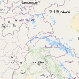

Leaflet | © OpenStreetMap contributors
Time
Current local time in Ağdaş:
Time: 16:24 +04
Date: 2025-02-23
Sunrise and Sunset
| Date | Sunrise | Sunset |
|---|---|---|
| 2025-02-23 (Today) | 07:31 | 18:35 |
| 2025-02-24 (Tomorrow) | 07:29 | 18:36 |
| 2025-02-25 | 07:28 | 18:37 |
| 2025-02-26 | 07:26 | 18:39 |
| 2025-02-27 | 07:25 | 18:40 |
| 2025-02-28 | 07:23 | 18:41 |
| 2025-03-01 | 07:22 | 18:42 |