
Cities close to Mooloolaba
Cities, towns and suburbs near Mooloolaba. Brisbane: 88 kilometers (55 miles), Carrolls Creek: 258 kilometers (160 miles), Maitland: 690 kilometers (428 miles).
| Cities / towns / suburbs around Mooloolaba | Kilometers | Miles |
|---|---|---|
| How far is Brisbane from Mooloolaba | 88 | 55 |
| How far is Carrolls Creek from Mooloolaba | 258 | 160 |
| How far is Maitland from Mooloolaba | 690 | 428 |
| How far is Parramatta from Mooloolaba | 819 | 509 |
| How far is Sydney from Mooloolaba | 820 | 509 |
| How far is Katoomba from Mooloolaba | 828 | 514 |
| How far is Liverpool from Mooloolaba | 832 | 517 |
| How far is Bowen from Mooloolaba | 893 | 555 |
Closest airport to Mooloolaba
| Airport | Kilometers | Miles |
|---|---|---|
| Sunshine Coast Airport (MCY) | 9.2 | 5.7 |
| Brisbane Airport (BNE) | 78.2 | 48.6 |
| Maryborough Airport (MBH) | 136.2 | 84.6 |
Distance from Mooloolaba to other municipalities
| Municipality | Kilometers | Miles |
|---|---|---|
| How far is Woodridge from Mooloolaba | 106 | 66 |
| How far is Mackay from Mooloolaba | 734 | 456 |
| How far is Logan City from Mooloolaba | 106 | 66 |
| How far is Southbank from Mooloolaba | 1 455 | 904 |
Location
Coordinates:
Latitude: 26°40′53″S
Longitude: 153°7′9″E
Map
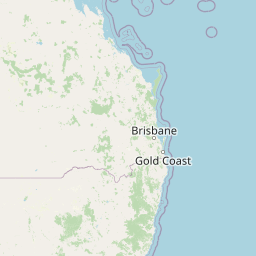


Leaflet | © OpenStreetMap contributors
Time
Current local time in Mooloolaba:
Time: 06:44 AEST
Date: 2025-02-19
Sunrise and Sunset
| Date | Sunrise | Sunset |
|---|---|---|
| 2025-02-19 (Today) | 05:33 | 18:29 |
| 2025-02-20 (Tomorrow) | 05:34 | 18:28 |
| 2025-02-21 | 05:34 | 18:27 |
| 2025-02-22 | 05:35 | 18:26 |
| 2025-02-23 | 05:35 | 18:25 |
| 2025-02-24 | 05:36 | 18:24 |
| 2025-02-25 | 05:37 | 18:23 |