
Cities close to Goodna
Cities, towns and suburbs near Goodna. Sunshine Coast: 108 kilometers (67 miles), Carrolls Creek: 156 kilometers (97 miles), Maitland: 584 kilometers (363 miles).
| Cities / towns / suburbs around Goodna | Kilometers | Miles |
|---|---|---|
| How far is Sunshine Coast from Goodna | 108 | 67 |
| How far is Carrolls Creek from Goodna | 156 | 97 |
| How far is Maitland from Goodna | 584 | 363 |
| How far is Parramatta from Goodna | 714 | 443 |
| How far is Sydney from Goodna | 714 | 444 |
| How far is Katoomba from Goodna | 723 | 449 |
| How far is Liverpool from Goodna | 727 | 452 |
| How far is Canberra from Goodna | 925 | 575 |
| How far is Bowen from Goodna | 968 | 601 |
Closest airport to Goodna
| Airport | Kilometers | Miles |
|---|---|---|
| Brisbane Airport (BNE) | 33.1 | 20.6 |
| Gold Coast Airport (OOL) | 85.8 | 53.3 |
| Toowoomba Wellcamp Airport (WTB) | 109.2 | 67.9 |
Distance from Goodna to other municipalities
| Municipality | Kilometers | Miles |
|---|---|---|
| How far is Cleveland from Goodna | 37 | 23 |
| How far is Tamborine Mountain from Goodna | 50 | 31 |
| How far is Wellington Point from Goodna | 37 | 23 |
Location
Coordinates:
Latitude: 27°36′37″S
Longitude: 152°53′56″E
Map
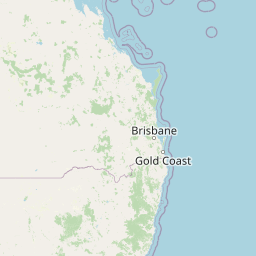


Leaflet | © OpenStreetMap contributors
Time
Current local time in Goodna:
Time: 00:42 AEST
Date: 2025-03-22
Sunrise and Sunset
| Date | Sunrise | Sunset |
|---|---|---|
| 2025-03-22 (Today) | 05:51 | 17:58 |
| 2025-03-23 (Tomorrow) | 05:52 | 17:57 |
| 2025-03-24 | 05:52 | 17:56 |
| 2025-03-25 | 05:53 | 17:55 |
| 2025-03-26 | 05:53 | 17:54 |
| 2025-03-27 | 05:54 | 17:53 |
| 2025-03-28 | 05:54 | 17:52 |