
Cities close to Cleveland
Cities, towns and suburbs near Cleveland. Sunshine Coast: 98 kilometers (61 miles), Carrolls Creek: 184 kilometers (114 miles), Maitland: 602 kilometers (374 miles).
| Cities / towns / suburbs around Cleveland | Kilometers | Miles |
|---|---|---|
| How far is Sunshine Coast from Cleveland | 98 | 61 |
| How far is Carrolls Creek from Cleveland | 184 | 114 |
| How far is Maitland from Cleveland | 602 | 374 |
| How far is Sydney from Cleveland | 732 | 455 |
| How far is Parramatta from Cleveland | 732 | 455 |
| How far is Katoomba from Cleveland | 744 | 463 |
| How far is Liverpool from Cleveland | 746 | 463 |
| How far is Canberra from Cleveland | 947 | 589 |
| How far is Bowen from Cleveland | 979 | 608 |
Closest airport to Cleveland
| Airport | Kilometers | Miles |
|---|---|---|
| Brisbane Airport (BNE) | 21.6 | 13.4 |
| Gold Coast Airport (OOL) | 74.8 | 46.5 |
| Sunshine Coast Airport (MCY) | 104.2 | 64.8 |
Distance from Cleveland to other municipalities
| Municipality | Kilometers | Miles |
|---|---|---|
| How far is Dalby from Cleveland | 202 | 125 |
| How far is Blackburn from Cleveland | 1 372 | 853 |
| How far is Bentley from Cleveland | 3 621 | 2 250 |
| How far is Melton from Cleveland | 1 390 | 864 |
| How far is Melton West from Cleveland | 1 391 | 864 |
| How far is Bowen from Cleveland | 979 | 608 |
| How far is Canterbury from Cleveland | 1 376 | 855 |
Location
Coordinates:
Latitude: 27°31′36″S
Longitude: 153°15′54″E
Map
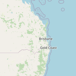


Leaflet | © OpenStreetMap contributors
Time
Current local time in Cleveland:
Time: 04:39 AEST
Date: 2025-03-14
Sunrise and Sunset
| Date | Sunrise | Sunset |
|---|---|---|
| 2025-03-14 (Today) | 05:46 | 18:06 |
| 2025-03-15 (Tomorrow) | 05:46 | 18:05 |
| 2025-03-16 | 05:47 | 18:04 |
| 2025-03-17 | 05:47 | 18:03 |
| 2025-03-18 | 05:48 | 18:01 |
| 2025-03-19 | 05:48 | 18:00 |
| 2025-03-20 | 05:49 | 17:59 |